Monday, June 30, 2008

Summer Training Log - Week of June 30, 2008 - Goal Reached

I have accumulated only 400-500 miles since the middle of April. A wedding and extensive business travel in May impacted time on the bike. I am not complaining but going forward, I plan to devote more time to cycling in preparation for the Glacier National Park ride in August and for the up coming Tour of Tucson in November.

Goals:


  • Ride 150 miles per week
  • Lose 15 lbs
  • Ride both sides of Usury Pass 3 times on one continuous ride; average up hill speed of 13 miles per hour

Saturday, June 28, 2008

Miles: 30
Weight: 175
Route: Sossoman to University. University to Ellesworth. Ellworth to the top of Usury Pass down to about 3600 n and then back up to the summit of Usury three times. Summit to Thomas. Thomas to 88th. 88th to University. University to Sossoman and home.

Monday, June 30, 2008

Miles: 40
Route: Sossoman to Guadalupe. Guadalupe to Crismon. Crismon to Baseline. Baseline to Goldfield Road. Goldfield to Lost Duchman/Brown. Brown to Ellsworth. Ellsworth to top of Usury Pass. Top of Usury Pass to Thomas. Thomas to 88th. 88th to University. University to Sossoman. Sossaman to home.

Tuesday, July 1, 2008
Cardio - Eliptical Trainer: 30 minutes
Stretching
Sit ups

Wednesday, July 2, 2008
Miles: 20
Route: Sossoman to University, University to Recker, through Las Sendas, down Power to University, University to Sossaman.

I didn't have that much time this morning which was too bad. Today was one of those rare days when all the cylinders are firing at the same time. I had reserve and my recovery was good. I could have ridden for hours. I experienced the pure enjoyment of riding.

Thursday, July 3, 2008

Miles: 30
Avg Speed: (up Usury - 12 mph)
Weight: 173

Route: Sossoman to University, University to Ellsworth, Ellsworth to the summit of Usury Pass (rode Usury twice). Back home the same way.

Friday, July 4, 2008

Miles: 30 - Achieved the goal for the week of 150 miles!!

Route: I was in Prescott on the evening of the 3rd and the 4th with Sandy, Becky and Lindsay. The weather was fabulous. The high was about 85. At the time of my morning ride the temperature was in the low 70s. Wow! The ride was so comfortable. I took a circular route leaving the Holiday Inn Express and going east for about 6 miles then north to highway 89A. From this point traveling west to the turn off to Prescott. From the turnoff heading south up a long slow grade to the main drag in Prescott. Then turning east again and up the final grade to the hotel.

This was a good work out at elevation and with long, slow burning grades. I really love the Prescott Valley as a place to ride. Great roads, wide-open spaces, variety in terrain and great scenery.
Sunday, June 29, 2008

The Road Through Glacier National Park

In preparation for my ride through Glacier National Park, I have been learning about the riding conditions on the Going-To-The-Sun road. This ride is going to be an adventure! This summer is the 75th anniversary of the opening of the road. The road has been maintained but the basic configuration has not changed over the years.

The route from St. Mary to West Glacier is approximately 56 miles with over 5,000 feet of elevation change; 2,100 foot acent over 18 miles to the summit and then a 3,500 foot descent over 32 miles. Good thing we are riding from east to west.

The road was opened 75 years ago this summer and was designed for the truck capabilities of the 1920's. The grades are a fairly consistant at 6%. This means a good slow burn in low gears. Being fit will make the ride a lot more pleasant and fun. I understand that the first 6 miles out of St. Mary to Rising Sun can be brutal due to the headwinds that howl through the St. Mary Valley down from the Continental Divide. (I really don't like headwinds especially howling winds). An 18 mile ascent to Logan Pass begins after passing through this point.

This is not a ride for inexperienced cyclist. There is no shoulder on this road. The engineers and builders did not anticipate cyclists nor did they have the tools and resources to build the road any wider than it is. Riders need to be comfortable riding between motorists and several thousand foot drop offs. There are low retaining walls to provide some barrier but the possibility of being pitched over this low wall is real. The pavement can be rough due to the effects of the harsh winter. Sections of the road are typically under construction at this time of the year given a limited window of time to make repairs. This is not good for skinny tire cyclists! Helmets are always essential riding gear but on this road helmets are important to protect against falling rock! I have learned that near the summit that we may share the road with mountain goats.

Given these conditions, the ride will start early in the morning to avoid as much traffic as possible. In fact, we have to make it through a certain point in the park by 11am before the road is closed to cyclists.

Once we arrive in West Glacier, we will still have 30 more miles to Big Fork, Montana., our final destination, on the north end of Flathead Lake. By this point in the ride most of the excitement will be behind us. I anticipate that the ride will take up to 5 hours depending on scenery stops.

Saturday, June 28, 2008

Prep for Logan Pass, Glacier Park

Training for my Glacier National Park ride is coming along well. Now that I have a couple hundred miles on the saddle, I am shifting my training routine to include more grades.
I rode this morning for 30 miles. I rode the south side of Usury Pass on Ellesworth 3 times. http://www.roadbikerides.com/ride/view/usery_pass/190
I got on the road late due to finding my rear tire flat. By the time I finished the ride the sun was much higher in the sky than I like and temperatures were climbing. I got toasted just a little!
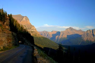
The picture below is what I plan to ride at the end of August.


Monday, June 23, 2008

Becky Graduates!


Congratualtions, Becky, on your recent HS graduation.

Sunday, June 22, 2008

This Blog is Now Open To All Readers

I have edited earlier postings, eliminated a few pictures and done some other cleanup to mitigate the need to make this blog private.

It has been a pain in the neck for invited readers to sign in. Readership is way down. I have lost motivation to publish since the blog was intended partly to be accessible on the web so other Boizelle's (Boiselle's) could connect with me.

The effort of inviting readers and controlling the list is a pain. Bottom line...I will simply be careful in what I post and what details I include about my family members.

My site contains several links to blogs of other family, friends and relatives. If those individuals do not want their blog link open to everyone on the web, please let me know and I will remove it from view.

Saturday, June 14, 2008

Waterton Lakes National Park

http://picasaweb.google.com/DaveBoizelle/AlbertaCanada

Just a few miles west of Cardston, Alberta, Canada is Canada's fourth national park - Waterton Lakes National Park. This park was formed in 1895 and was named after Waterton Lake. It borders the US and Glacier National Park in Montana. The park covers about 200 square miles of rugged mountains and wilderness.

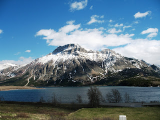
The park is very diverse for its size having prairie, apsen and alpine forests, tundra and high meadows. The primary feature of this park is Waterton Lake, the deepest in the Canadian Rockies. The peak to the right is Vimy.


To the right is the Prince of Wales Hotel, notebly, one of the nost photographed hotels in North America. The hotel is set on a bluff above Waterton Lake. The hotel apparently offers a true British experience including an afternoon tea. We were not able to enter and look around as it was under renovation.


The wildlife is abundant! Just about everywhere in the park, wildlife strolled like pedestrians. There are over 60 species of mammals, 250 species of birds, 24 species of fish and nearly a dozen types of reptiles.

Apparently, this park, in conjunction with Glacier National park to the south, is a extremely important wildlife corridor. A number of differnet ecological regions that meet and overlap in the park. According to one web site, the park contains 45 different habitats within 200 square miles.


Cameron Falls is located in the townsite of Waterton. The setting is restful and inspiring. Some of the exposed rock around the falls site can be dated back to precambrian time; about 1.5 billion years ago. The power of water on geology is very evident. Wait long enough and water will wear you down!


These mountains are some of the oldest mountains in North America. An incredible example of fault block effect. The peak in this picture is Aldersen Peak. In the foreground is another view of the Prince of Wales Hotel.

Can you imagine having afternoon tea (herbal) in the hotel while looking out at this peak and the lake?


Another look at Aldersen Peak in the middle flanked by sister peaks.


A picture of Red Rock Canyon. On a small scale, it has a Sedona, AZ feel. The rock coloring is very similar. The canyon is set among the alpine meadows and jagged mountain peaks. We did not explore this canyon much in that we were short on time. If we had more time we could have hiked a short distance to Blakison Falls. The peak in the background is Dungarvin Peak.

This is one park that we will come back to see again.

Tuesday, June 10, 2008

Jon and Stephanie's Wedding

Jon and Stephanie wedding festivities turned out very well. It took about 9 days and 2600 miles to get it completed but it was well worth it. Jon married a wonderful girl named Stephanie Quinton. She comes from a great family.

I have a few pictures from the wedding in Rexburg, Idaho and some from the receptions in Logan, Utah. The camera settings must not have been correct as a few of the pictures are hazy.

The Rexburg temple was beautiful inside and out. The weather was gorgeous and so was the bride!